|
Tribal Assessment |
|
The Great Basin |
|
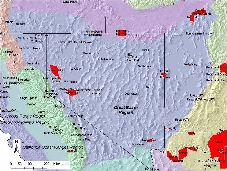
| Since we wanted to
statistically derive a correlation matrix for each region, we needed at
least four sites to in the correlation. There are five sites within
the region based on the physiographic boundaries. We decided to
include ZION1 in the correlation since it was located on the western portion
of Zion National Park. The site has since moved to Zion Canyon, ZICA1. IMPROVE and IMPROVE
protocol sites used in this analysis are shown in this
map. |
|
| The details of the
correlation analysis are provided in tabular format below. The
Representative Distance (Rep. Dist.) is 98 km for this region.
Representative distances were based from exponential curve fits to the
correlation verses
distance curves. |
|
| Region |
|
Sulfate |
NO3 |
OMC |
LAC |
Soil |
CM |
Rep. Dist. |
| Great Basin |
Distance (km) |
161.5 |
86.5 |
39.8 |
0.0 |
285.6 |
99.7 |
|
| |
Average (Mm-1) |
4.6 |
2.3 |
4.8 |
1.6 |
0.9 |
2.9 |
|
| |
Weighting |
0.270 |
0.132 |
0.281 |
0.095 |
0.054 |
0.168 |
|
| |
Weighted Dist. (km) |
43.6 |
11.4 |
11.2 |
0.0 |
15.5 |
16.8 |
98 |
|
|
| Based on a representative
distance of 98 km, 29 tribal areas in the region are not represented by
an IMPROVE or IMPROVE protocol site as shown in this
summary map. |
|
 |
|
|
The following links take you to the Causes of Haze Assessment using the
1997 to 2002 data.
The following class I area is in the Great Basin region:
Jarbidge Wilderness Area
The following IMPROVE sites are in the region:
Great Basin National Park
Walker River Tribe
Death Valley National Park |