|
| |
|
U.S.
Fish & Wildlife Service Assessment
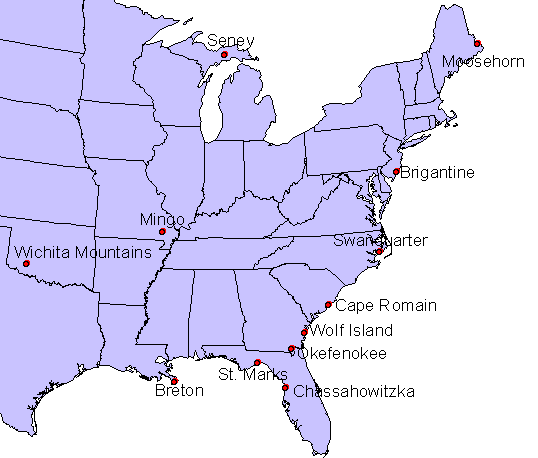
DRI is tasked to complete a Causes of Haze Assessment at Fish & Wildlife
Service Class I areas in the eastern and central US. This assessment covers
the areas as shown in the map below.
Click on a site in the map to access results for each Class I area or
consult the links below
to access the results by task.
|
|
Task 1: Site Setting
For each of the 12 Fish & Wildlife class I areas in the eastern and
central US, DRI will complete a
description of local area geography, climatology, nearby land use and nearby
regional sources. This will include a combination of maps (e.g. land use,
terrain, sources) and some descriptive material (e.g. climatology, setting
of site). |
| |
Task 2: Aerosol Summary and
Trends Analysis
For each of the 12 Fish & Wildlife class I areas DRI will complete an
analysis of aerosol data collected on site or representative of the class I
area. |
| |
Task 3: Backtrajectory
Analysis
We have run eight day HYSPLIT backtrajectories spanning the year from 2000
to 2004. Eight trajectories were run per day with a starting height of 500 m
AGL. To allow for an understanding of transport climatology, backtrajectory
residence time maps have been created for all days, 20% best days, 20% worst
days, and 20% worst days for sulfate, organic carbon, elemental carbon, fine
soil, nitrate, and coarse mass. We have also generated conditional
probability maps that show the likelihood that backtrajectories from a given
area were associated with 20% worst days for each major component. |
| |
Task 4: Positive Matrix
Factorization (PMF) Analysis
We have run the PMF model and interpret the results for each site. For
nearby sites (such as Okefenokee, St. Marks, and Chassahowitzka), it may be
advantageous to group the sites for determining the factors and then
calculating daily factor scores and the overall contribution of each factor.
By combining sites we may be more able to clearly separate out sources that
may be highly collinear at individual sites. |
| |
Task 5: PMF Weighted
Backtrajectory Analysis
PMF factor score weighted backtrajectory summaries are presented here to better define PMF
factors and relate them to sources. |
| |
Task 6: Conceptual
Models
We will review all maps, data, and modeling results produced under tasks 1-4
and develop conceptual models for each site. The conceptual model is our
attempt to explain what source areas and source types cause haze at these
National Wildlife Refuges and how they varies seasonally and year-to-year. |
| |
| |
| |
| |
| |
| |
Page last updated 23 January 2007
|

