|
| |
|
Tribal Assessment |
|
The Southern California Ranges
(printer friendly version) |
|
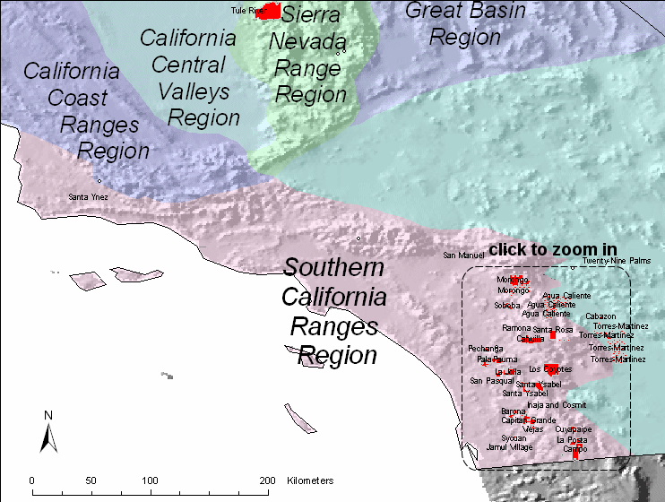
| Since we wanted to
statistically derive a correlation matrix for each region, we needed at
least four sites to in the correlation. There are four sites within
the region based on the physiographic boundaries. IMPROVE and IMPROVE
protocol sites used in this analysis are shown in this
map. |
|
| The details of the
correlation analysis are provided in tabular format below. The
Representative Distance (Rep. Dist.) is 101 km for this region.
Representative distances were based from exponential curve fits to the
correlation verses
distance curves. |
|
| Region |
|
Sulfate |
NO3 |
OMC |
LAC |
Soil |
CM |
Rep. Dist. |
| Southern California Ranges |
Distance (km) |
189.7 |
65.1 |
83.7 |
46.0 |
117.7 |
30.7 |
|
| |
Average (Mm-1) |
11.6 |
12.6 |
6.7 |
2.8 |
0.8 |
4.5 |
|
| |
Weighting |
0.299 |
0.323 |
0.172 |
0.072 |
0.020 |
0.116 |
|
| |
Weighted Dist. (km) |
56.6 |
21.0 |
14.4 |
3.3 |
2.3 |
3.6 |
101 |
|
|
| Based on a representative
distance of 101 km, one tribal area in the region is not represented by
an IMPROVE or IMPROVE protocol site as shown in this
summary map. |
|
 |
|
|
The following Class I areas are in the Southern California
Ranges region:
Agua Tibia Wilderness
Area
Cucamonga Wilderness
Area
San Gabriel Wilderness Area
San Gorgonio Wilderness Area
San Jacinto Wilderness Area
Terrain of southern California is characterized by coastal air basins,
principally the South Coast Air Basin, and surrounding mountain ranges.
Generally the area is bounded on the north by the San Gabriel Mountains. Several
openings lead to the more interior valleys and the Mohave Desert. Under some
conditions, these openings provide transport corridors for air pollution even
under severe stagnation conditions that prevent vertical mixing and upper level
transport.
The climate of this region is heavily influenced by the semi-permanent
combination of Pacific anticyclone and ‘thermal’ low pressure that extends up
from Mexico into the California Valley in summer and begins to break down in
fall. Typically, by late September, mid-latitude transient weather systems start
to invade the California coastline – affecting the northern California coast
first and later in the season the southern California coastline. These transient
systems continue to impact the coast until early April. Yet, the very cold/dry
penetrations that affect the southern California coast do not typically begin
until early December (late fall). These cold/dry penetrations are usually
associated with northwesterly flow, and the South Coast Air Basin is usually
scoured of pollutants during these episodes.
The synoptic weather situations that favor increases in pollution are the
quiescent periods when steady-state high pressure (anticyclones) cover the
southern half of California. During such periods, especially within the Los
Angeles area almost completely enclosed by mountains on the north and east, the
vertical temperature structure (inversion) tends to prevent vertical mixing of
the air through more than a shallow layer (1,000 to 2,000 feet deep). The
geographical configuration and the southerly location of the Basin permit a
fairly regular daily reversal of wind direction—offshore at night and onshore
during the day. This is especially true close to the coastline, less pronounced
at more interior areas. Winds during these anticyclonic situations are typically
quite low in speed, on the order of 5 mph or less.
With the concentrated population and industry, pollution products tend to
accumulate and remain within this circulation pattern until ventilated. When
transported to distant regions, either through vertical mixing and upper level
transport, or through low level transport through passes and corridors into the
Mojave interior, the region is a major source region for pollutants including
particulate matter
References
1997 Southern California Ozone Study (SCOS97) Study Plan
Weekend/Weekday Nitrate Study
State Climatologist (through National Climatic Data Center)
|
Last updated 21 January 2005
|