|
| |
|
Task 2: Analysis considering height of interveining terrain
|
| 2.2 Methodology |
|
| We generated 48-hour forward
and backward trajectories using one year of EDAS-40 kilometer meteorological
model input. The trajectories were run every 3-hours so as to make eight
trajectories per day. For each trajectory the model calculates hourly
endpoints and provides it as latitude and longitude pairs. The HYSPLIT model
requires the specification of trajectory starting height for each
trajectory. Based from work completed for the WRAP Causes of Haze
Assessment, we opted to run HYSPLIT at 500 meters above the ground. We
choose the year 2005 to run in the model since it is a recent dataset with
very few missing hours. These trajectories were calculated at each IMPROVE
and IMPROVE protocol monitoring sites in the WRAP region. The model was run
at a total of 109 monitoring sites in the western and bordering central US.
Buffer zones were calculated around tribal centroids. The buffer zones
distances were obtained from the results in section 4 where the spatial
representativness was determined by inter-site correlation. We used buffer
zones around a central point or centroid of the tribe to simplfy the
calculations between the trajectories and tribal boundaries. An example of
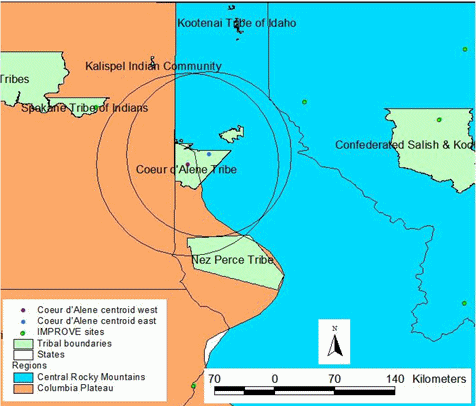
this method can be seen below in Figure 4-1 with the Coeur d’Alene tribe in
northern Idaho. |
 |
|
| For several tribes there were
several parts of the tribal boundary based on the GIS data. One such example
is the shown in Figure 8 above. In this case the Coeur d’Alene tribe was
divided into two areas as well as in two physiographic regions. The larger
area to the south was split between the Central Rocky Mountain region and
the Columbia Plateau region. The smaller area to the north was in the
Central Rocky Mountain region. Here we calculated a circular buffer zone of
106 km around the region in the Columbia Plateau and one of 96 km in the
Central Rocky Mountain region. |
|
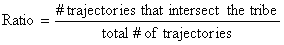
| After a buffer zone was
generated for each tribe, we performed calculations with the trajectories to
compare each tribe with each IMPROVE site. A useful measure of
representativness was defined as the ratio of the number of trajectories
that intersect the tribal buffered area divided by the total number of
trajectories that were run. |
|
|
|
|
| This provides a way to gauge
the air mass similarites between the tribe and a IMPROVE aerosol monitoring
site. If every trajectory, both forward and backward, intersected the tribe
then the ratio would be equal to one. This is the case when the tribe is
close to an IMPROVE site and it may even be within the tribal buffer zone or
representative distance. Recall from section 4 of this report that the
tribal representative distances range from 238 km in the California Coast
Ranges to 90 km in the Southern Rocky Mountains region. We used a strict
minimum representativeness threshold as the ratio to be equal to one (Ratio
= 1). |
|
|
|
|
Last updated 21 March 2008
|