| Year |
|
1994 |
1995 |
1996 |
1997 |
1998 |
1999 |
2000 |
2001 |
2002 |
2003 |
|
Slope
(1/Mm/Year) |
P-Value |
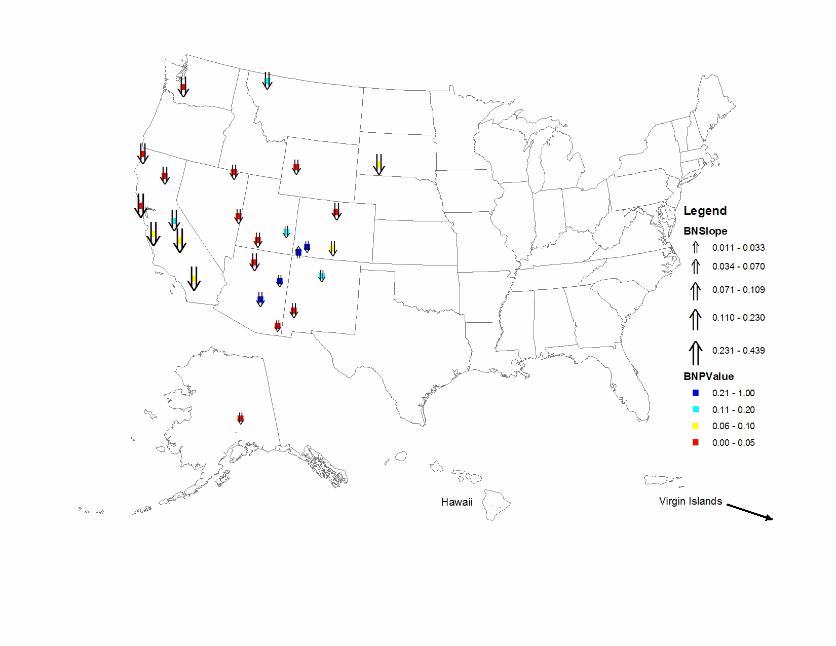
| BADL1 |
Badlands National Park |
3.681 |
3.602 |
1.769 |
0.767 |
1.166 |
1.236 |
1.499 |
1.815 |
1.003 |
0.869 |
|
-0.178 |
0.054 |
| BAND1 |
Bandelier National Monument |
1.187 |
1.161 |
0.918 |
0.533 |
0.792 |
0.538 |
0.870 |
0.658 |
1.066 |
0.857 |
|
-0.026 |
0.190 |
| BRCA1 |
Bryce Canyon National Park |
1.491 |
1.451 |
1.057 |
0.688 |
0.685 |
0.661 |
0.719 |
0.862 |
0.840 |
0.566 |
|
-0.070 |
0.023 |
| BRID1 |
Bridger Wilderness |
0.877 |
0.878 |
0.638 |
0.456 |
0.549 |
0.434 |
0.417 |
0.522 |
0.498 |
0.410 |
|
-0.047 |
0.005 |
| CANY1 |
Canyonlands National Park |
1.137 |
1.195 |
0.730 |
0.535 |
0.589 |
0.496 |
0.463 |
0.659 |
0.875 |
0.634 |
|
-0.033 |
0.146 |
| CHIR1 |
Chiricahua National Monument |
0.842 |
0.856 |
0.764 |
0.578 |
0.734 |
0.525 |
0.521 |
0.619 |
0.628 |
0.503 |
|
-0.033 |
0.008 |
| DENA1 |
Denali National Park |
0.345 |
0.349 |
0.236 |
0.262 |
0.098 |
0.134 |
0.151 |
0.135 |
0.143 |
0.100 |
|
-0.027 |
0.023 |
| GICL1 |
Gila Wilderness |
0.688 |
0.694 |
0.621 |
0.341 |
0.369 |
0.393 |
0.494 |
0.420 |
0.320 |
0.220 |
|
-0.046 |
0.014 |
| GLAC1 |
Glacier National Park |
1.937 |
1.983 |
1.397 |
0.929 |
0.961 |
0.836 |
0.968 |
0.998 |
0.877 |
1.035 |
|
-0.087 |
0.146 |
| GRBA1 |
Great Basin National Park |
0.857 |
0.822 |
0.625 |
0.358 |
0.390 |
0.286 |
0.384 |
0.423 |
0.309 |
0.325 |
|
-0.053 |
0.014 |
| GRSA1 |
Great Sand Dunes National Monument |
1.213 |
1.146 |
0.782 |
0.573 |
0.839 |
0.544 |
0.664 |
0.616 |
0.964 |
0.585 |
|
-0.048 |
0.078 |
| INGA1 |
Indian Gardens |
1.437 |
1.320 |
1.167 |
0.708 |
0.676 |
0.534 |
0.440 |
0.686 |
0.690 |
0.445 |
|
-0.106 |
0.005 |
| JARB1 |
Jarbidge Wilderness |
0.859 |
0.817 |
0.867 |
0.427 |
0.289 |
0.271 |
0.279 |
0.415 |
0.228 |
0.355 |
|
-0.058 |
0.014 |
| LAVO1 |
Lassen Volcanic National Park |
1.588 |
1.282 |
0.830 |
0.331 |
0.275 |
0.321 |
0.606 |
0.420 |
0.411 |
0.279 |
|
-0.109 |
0.023 |
| MEVE1 |
Mesa Verde National Park |
0.900 |
0.916 |
0.997 |
0.447 |
0.564 |
0.608 |
0.799 |
0.754 |
1.098 |
0.980 |
|
0.025 |
0.242 |
| MORA1 |
Mount Rainier National Park |
2.583 |
2.655 |
1.621 |
0.649 |
0.622 |
0.532 |
0.747 |
0.853 |
0.577 |
0.562 |
|
-0.154 |
0.014 |
| PEFO1 |
Petrified Forest National Park |
1.042 |
1.009 |
1.022 |
0.576 |
0.795 |
0.603 |
0.772 |
1.100 |
0.955 |
0.761 |
|
-0.011 |
0.242 |
| PINN1 |
Pinnacles National Monument |
7.125 |
8.132 |
4.827 |
2.358 |
2.612 |
2.985 |
3.337 |
2.451 |
2.422 |
2.809 |
|
-0.401 |
0.054 |
| PORE1 |
Point Reyes National Seashore |
7.327 |
7.325 |
4.074 |
2.388 |
1.755 |
1.549 |
2.116 |
1.865 |
2.047 |
2.059 |
|
-0.420 |
0.023 |
| REDW1 |
Redwood National Park |
3.175 |
3.158 |
1.991 |
1.030 |
0.718 |
0.798 |
0.849 |
0.794 |
0.612 |
0.521 |
|
-0.230 |
0.000 |
| ROMO1 |
Rocky Mountain National Park |
1.180 |
1.216 |
0.622 |
0.235 |
0.394 |
0.215 |
0.608 |
0.327 |
0.273 |
0.282 |
|
-0.095 |
0.036 |
| SAGO1 |
San Gorgonio Wilderness |
18.000 |
18.477 |
4.537 |
1.610 |
2.664 |
2.411 |
2.871 |
2.527 |
2.894 |
1.829 |
|
-0.387 |
0.078 |
| SEQU1 |
Sequoia National Park |
11.698 |
12.417 |
5.178 |
2.336 |
1.107 |
3.869 |
4.255 |
2.851 |
3.424 |
2.985 |
|
-0.439 |
0.078 |
| TONT1 |
Tonto National Monument |
1.580 |
1.606 |
1.253 |
0.669 |
0.753 |
1.020 |
0.818 |
1.318 |
0.981 |
1.185 |
|
-0.044 |
0.300 |
| WEMI1 |
Weminuche Wilderness |
0.730 |
0.699 |
0.361 |
0.306 |
0.254 |
0.338 |
0.542 |
0.318 |
0.512 |
0.423 |
|
-0.027 |
0.242 |
| YOSE1 |
Yosemite National Park |
2.958 |
3.161 |
1.761 |
0.451 |
0.485 |
0.599 |
0.383 |
0.632 |
0.818 |
0.531 |
|
-0.215 |
0.146 |