| Year |
|
1994 |
1995 |
1996 |
1997 |
1998 |
1999 |
2000 |
2001 |
2002 |
2003 |
|
Slope
(1/Mm/Year) |
P-Value |
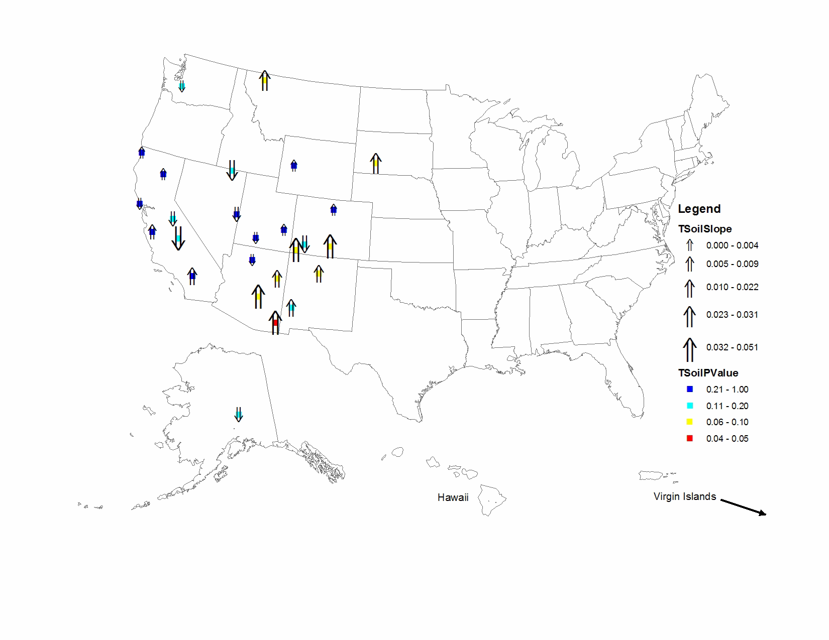
| BADL1 |
Badlands National Park |
0.502 |
0.405 |
0.468 |
0.405 |
0.496 |
0.574 |
0.563 |
0.732 |
0.657 |
0.489 |
|
0.027 |
0.054 |
| BAND1 |
Bandelier National Monument |
0.510 |
0.496 |
0.616 |
0.491 |
0.548 |
0.633 |
0.421 |
0.679 |
0.713 |
0.625 |
|
0.017 |
0.078 |
| BRCA1 |
Bryce Canyon National Park |
0.625 |
0.562 |
0.592 |
0.406 |
0.413 |
0.519 |
0.501 |
0.555 |
0.687 |
0.502 |
|
-0.004 |
0.431 |
| BRID1 |
Bridger Wilderness |
0.429 |
0.291 |
0.461 |
0.254 |
0.354 |
0.491 |
0.293 |
0.470 |
0.452 |
0.364 |
|
0.003 |
0.300 |
| CANY1 |
Canyonlands National Park |
0.668 |
0.570 |
0.679 |
0.515 |
0.536 |
0.636 |
0.515 |
0.653 |
1.216 |
0.543 |
|
0.000 |
0.500 |
| CHIR1 |
Chiricahua National Monument |
0.774 |
0.825 |
0.963 |
0.714 |
0.769 |
0.919 |
0.997 |
0.793 |
1.168 |
1.154 |
|
0.041 |
0.036 |
| DENA1 |
Denali National Park |
0.173 |
0.177 |
0.171 |
0.150 |
0.214 |
0.214 |
0.105 |
0.167 |
0.155 |
0.112 |
|
-0.006 |
0.108 |
| GICL1 |
Gila Wilderness |
0.640 |
0.698 |
0.695 |
0.519 |
0.637 |
0.721 |
0.922 |
0.745 |
0.850 |
0.661 |
|
0.015 |
0.108 |
| GLAC1 |
Glacier National Park |
0.626 |
0.412 |
0.532 |
0.430 |
0.610 |
0.529 |
0.509 |
0.676 |
0.727 |
0.685 |
|
0.026 |
0.054 |
| GRBA1 |
Great Basin National Park |
0.639 |
0.510 |
0.557 |
0.411 |
0.415 |
0.757 |
0.409 |
0.573 |
0.637 |
0.386 |
|
-0.006 |
0.242 |
| GRSA1 |
Great Sand Dunes National Monument |
0.538 |
0.920 |
0.958 |
0.611 |
0.615 |
0.752 |
0.901 |
0.790 |
1.150 |
0.941 |
|
0.038 |
0.054 |
| INGA1 |
Indian Gardens |
1.104 |
0.762 |
1.178 |
1.035 |
0.846 |
0.962 |
1.096 |
1.078 |
1.284 |
0.577 |
|
-0.001 |
0.500 |
| JARB1 |
Jarbidge Wilderness |
1.007 |
0.536 |
0.815 |
0.752 |
0.506 |
0.907 |
0.358 |
0.609 |
0.653 |
0.596 |
|
-0.031 |
0.146 |
| LAVO1 |
Lassen Volcanic National Park |
0.570 |
0.511 |
0.368 |
0.313 |
0.302 |
0.404 |
0.365 |
0.578 |
0.642 |
0.395 |
|
0.004 |
0.431 |
| MEVE1 |
Mesa Verde National Park |
0.645 |
0.595 |
1.062 |
0.538 |
0.558 |
0.626 |
0.668 |
0.887 |
1.160 |
1.040 |
|
0.044 |
0.054 |
| MORA1 |
Mount Rainier National Park |
0.193 |
0.187 |
0.195 |
0.180 |
0.198 |
0.171 |
0.161 |
0.316 |
0.179 |
0.174 |
|
-0.002 |
0.190 |
| PEFO1 |
Petrified Forest National Park |
0.648 |
0.704 |
0.943 |
0.767 |
0.706 |
0.756 |
0.691 |
0.758 |
1.143 |
0.954 |
|
0.022 |
0.054 |
| PINN1 |
Pinnacles National Monument |
0.331 |
0.397 |
0.400 |
0.476 |
0.368 |
0.426 |
0.391 |
0.595 |
0.456 |
0.313 |
|
0.009 |
0.300 |
| PORE1 |
Point Reyes National Seashore |
0.180 |
0.174 |
0.222 |
0.194 |
0.190 |
0.198 |
0.164 |
0.158 |
0.315 |
0.183 |
|
-0.001 |
0.500 |
| REDW1 |
Redwood National Park |
0.131 |
0.158 |
0.169 |
0.125 |
0.157 |
0.134 |
0.147 |
0.254 |
0.182 |
0.111 |
|
0.002 |
0.431 |
| ROMO1 |
Rocky Mountain National Park |
0.722 |
0.571 |
0.622 |
0.487 |
0.627 |
0.516 |
0.453 |
0.774 |
0.869 |
0.591 |
|
0.003 |
0.431 |
| SAGO1 |
San Gorgonio Wilderness |
0.482 |
0.798 |
0.829 |
1.071 |
0.692 |
0.886 |
0.690 |
0.801 |
1.087 |
0.638 |
|
0.017 |
0.364 |
| SEQU1 |
Sequoia National Park |
2.376 |
1.041 |
1.164 |
2.706 |
0.532 |
1.014 |
0.918 |
1.049 |
1.189 |
0.848 |
|
-0.042 |
0.190 |
| TONT1 |
Tonto National Monument |
0.798 |
0.913 |
1.091 |
0.793 |
0.842 |
0.811 |
1.405 |
0.913 |
1.428 |
1.343 |
|
0.051 |
0.054 |
| WEMI1 |
Weminuche Wilderness |
0.617 |
0.562 |
0.641 |
0.399 |
0.498 |
0.505 |
0.348 |
0.478 |
0.595 |
0.504 |
|
-0.013 |
0.190 |
| YOSE1 |
Yosemite National Park |
0.409 |
0.564 |
0.626 |
0.577 |
0.400 |
0.540 |
0.372 |
0.522 |
0.626 |
0.346 |
|
-0.007 |
0.190 |