| Year |
|
1994 |
1995 |
1996 |
1997 |
1998 |
1999 |
2000 |
2001 |
2002 |
2003 |
|
Slope
(1/Mm/Year) |
P-Value |
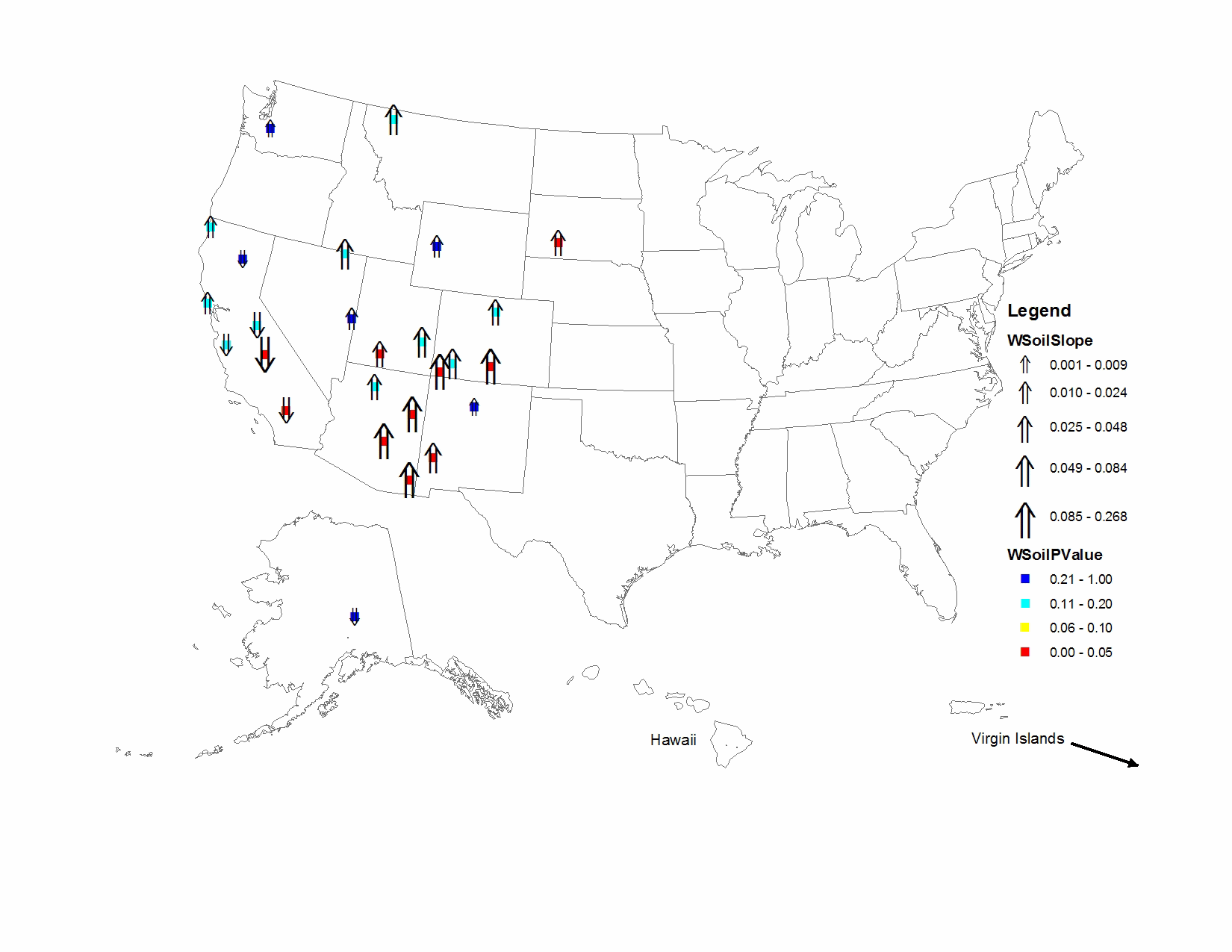
| BADL1 |
Badlands National Park |
0.800 |
0.700 |
0.579 |
0.605 |
0.712 |
0.852 |
1.041 |
1.343 |
1.138 |
0.714 |
|
0.048 |
0.036 |
| BAND1 |
Bandelier National Monument |
1.289 |
1.055 |
1.259 |
0.697 |
0.760 |
1.167 |
0.892 |
1.146 |
1.495 |
1.065 |
|
0.001 |
0.500 |
| BRCA1 |
Bryce Canyon National Park |
0.845 |
0.833 |
0.975 |
0.888 |
1.022 |
0.844 |
1.032 |
1.281 |
1.469 |
1.129 |
|
0.044 |
0.005 |
| BRID1 |
Bridger Wilderness |
1.094 |
0.574 |
0.933 |
0.594 |
0.898 |
1.025 |
0.904 |
1.452 |
1.050 |
0.716 |
|
0.018 |
0.300 |
| CANY1 |
Canyonlands National Park |
1.645 |
0.686 |
1.401 |
0.775 |
0.729 |
1.591 |
0.793 |
1.699 |
2.750 |
1.382 |
|
0.054 |
0.146 |
| CHIR1 |
Chiricahua National Monument |
1.494 |
1.117 |
1.394 |
0.684 |
1.245 |
1.583 |
2.814 |
2.571 |
2.379 |
3.626 |
|
0.265 |
0.014 |
| DENA1 |
Denali National Park |
0.261 |
0.348 |
0.324 |
0.207 |
0.190 |
0.313 |
0.208 |
0.519 |
0.378 |
0.184 |
|
-0.004 |
0.431 |
| GICL1 |
Gila Wilderness |
1.115 |
0.746 |
0.894 |
0.881 |
0.722 |
0.991 |
1.195 |
1.440 |
1.671 |
1.421 |
|
0.084 |
0.023 |
| GLAC1 |
Glacier National Park |
0.987 |
0.963 |
0.512 |
0.592 |
1.866 |
2.336 |
1.874 |
1.557 |
1.369 |
1.421 |
|
0.058 |
0.190 |
| GRBA1 |
Great Basin National Park |
1.616 |
1.010 |
1.271 |
0.817 |
1.061 |
1.293 |
1.361 |
1.617 |
1.571 |
0.900 |
|
0.017 |
0.300 |
| GRSA1 |
Great Sand Dunes National Monument |
2.233 |
1.134 |
2.105 |
1.629 |
1.402 |
1.797 |
2.750 |
2.369 |
2.814 |
3.146 |
|
0.166 |
0.014 |
| INGA1 |
Indian Gardens |
1.666 |
1.690 |
2.868 |
1.774 |
1.644 |
1.823 |
2.543 |
2.271 |
2.515 |
1.711 |
|
0.031 |
0.190 |
| JARB1 |
Jarbidge Wilderness |
2.379 |
1.470 |
2.724 |
1.130 |
2.666 |
2.450 |
1.822 |
2.854 |
3.031 |
1.923 |
|
0.063 |
0.190 |
| LAVO1 |
Lassen Volcanic National Park |
1.148 |
0.824 |
0.752 |
0.648 |
1.202 |
0.928 |
0.619 |
1.462 |
1.421 |
0.636 |
|
-0.002 |
0.500 |
| MEVE1 |
Mesa Verde National Park |
1.124 |
0.814 |
2.387 |
1.228 |
1.151 |
2.950 |
1.731 |
1.645 |
3.930 |
3.726 |
|
0.194 |
0.014 |
| MORA1 |
Mount Rainier National Park |
0.450 |
0.382 |
0.469 |
0.410 |
0.911 |
0.428 |
0.293 |
0.445 |
0.572 |
0.535 |
|
0.009 |
0.242 |
| PEFO1 |
Petrified Forest National Park |
1.135 |
1.109 |
1.171 |
1.905 |
0.889 |
1.754 |
1.520 |
1.648 |
2.793 |
2.990 |
|
0.181 |
0.014 |
| PINN1 |
Pinnacles National Monument |
0.550 |
0.679 |
0.767 |
0.652 |
0.615 |
0.883 |
0.651 |
0.542 |
0.617 |
0.463 |
|
-0.017 |
0.108 |
| PORE1 |
Point Reyes National Seashore |
0.290 |
0.300 |
0.388 |
0.297 |
0.445 |
0.585 |
0.483 |
0.291 |
0.571 |
0.355 |
|
0.024 |
0.108 |
| REDW1 |
Redwood National Park |
0.227 |
0.280 |
0.319 |
0.239 |
0.308 |
0.335 |
0.231 |
0.359 |
0.390 |
0.178 |
|
0.012 |
0.190 |
| ROMO1 |
Rocky Mountain National Park |
1.296 |
1.121 |
1.017 |
0.735 |
1.389 |
1.107 |
1.275 |
1.367 |
1.995 |
1.123 |
|
0.030 |
0.190 |
| SAGO1 |
San Gorgonio Wilderness |
1.212 |
1.331 |
1.202 |
1.248 |
1.059 |
0.979 |
1.203 |
1.196 |
1.036 |
0.947 |
|
-0.028 |
0.008 |
| SEQU1 |
Sequoia National Park |
18.422 |
1.690 |
4.445 |
2.441 |
1.384 |
1.094 |
0.848 |
0.965 |
0.921 |
1.579 |
|
-0.268 |
0.008 |
| TONT1 |
Tonto National Monument |
1.510 |
1.121 |
1.458 |
1.383 |
1.282 |
1.633 |
2.986 |
1.856 |
2.798 |
4.419 |
|
0.223 |
0.008 |
| WEMI1 |
Weminuche Wilderness |
0.891 |
0.783 |
0.798 |
0.792 |
0.757 |
0.995 |
0.688 |
1.245 |
1.682 |
1.439 |
|
0.077 |
0.108 |
| YOSE1 |
Yosemite National Park |
1.026 |
1.030 |
0.954 |
1.322 |
1.299 |
0.982 |
0.560 |
1.217 |
0.827 |
0.611 |
|
-0.029 |
0.108 |