|
The IMPROVE Network Hazagon |
|
|
| Description |
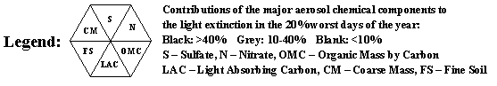
| The hazagon maps were created as a way to
visualize each measurement in the network by determining how the extinction
on that day ranks in comparison to all of the measurements over that year.
For those measurements that fall within the 20 percent worst category (i.e.
80th and greater percentiles), a site is represented by a hexagon divided
into six triangles. Each triangle represents the contribution of
sulfate, nitrate, organic mass by carbon, light absorbing carbon, fine soil,
and coarse mass to the total extinction. If a particular component
contributes more than 40 percent of the total extinction on that day, that
triangle is filled in with black. For components that contribute
between 10 to 40 percent to the total extinction that triangle is filled in
with grey. |
| |
|
 |
| |
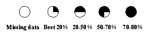
| For daily extinction categorized in the 0
to 80th percentile, the symbols are shown below. Missing data is
represented by a white circle. |
| |
|
 |
| |
| Uses of the animations |
| These animations provide a convenient way
to see both clean and haze episodes that vary over time and space. |
| |
| Example |
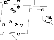
| Here is an example showing a portion of
the hazagon map from 2002. This map shows that one site was
characterized as a 20 percent worst day from that year. In this case, the
extinction calculated at Wichita Mountains was in the worst 20% with nitrate
contributing greater than 40 percent to the total extinction. Sulfate
contributed between 10 and 40 percent. |
| |
|
 |
| |
| In contrast, the six sites to the
southwest in New Mexico experienced extinction in the 20 percent best
category. The site northwest of Wichita Mountains did not collect data
and is represented by an open circle. |
| |
| Tips on viewing animations |
| On most PCs, files in the AVI file format
are readable by programs such as Real Player and the Windows Media player.
Click on the AVI link to open up the animation in the web browser. The
display of the animations will depend on your browser and configuration of
the animation player. If you don't have an animation player
application installed on your computer you can either install them at this
time or use the HTML link to view the animations. |
| |
| Clicking on the HTML link brings up the
animations using a javascript application. Since the application must
read in all of the files in the animation before starting, there will be a
delay before starting. This delay will depend on the speed at which
you are connected to the internet, network traffic and occasional web server
sluggishness. To best view the animations, maximize the window on your
screen. If you don't see the entire map image, you may have to change
the screen resolution so it fits. The advantages of using the HTML
viewer is that it allows you to stop the animation and save individual files
to your computer. |
| |
| back to
COHA reports |

