|
| |
|
Performance of HYSPLIT during wildfire events |
|
| Introduction |
| Smoke plumes are one example
of a tracer of opportunity to validate Lagrangian particle models. McQueen and Draxler (1994) used the Kuwait oil fires
to validate the HYSPLIT model using two meteorological inputs of differing
grid resolutions and found a 10 percent error with optimum model parameters.
Positive attributes of using smoke plumes include: relatively easy to obtain
source areas of large fires, can use visible satellite imagery without a
significant amount of image processing to identify plumes, and plumes from
wildfires are fairly easy to spot even over bright land surfaces. Negative
attributes of using smoke plumes include: using visible satellite imagery
limits use to daylight hours, unknown plume heights, difficult to identify
plume leading edge over land surface. |
|
 |
| |
| Plan |
| We propose the use of
wildfire smoke plumes to validate a trajectory model by computing a trajectory
ensemble and comparing to the smoke plume as seen from space. |
| |
| Smoke plume episodes are
chosen from selected GOES and MODIS satellite imagery during the time period
2000 to 2006. Aerosol optical depth products from the MODIS, Aura and GOES
will be useful to track plumes when they are not resolved in the visible
imagery. Satellite imagery will be brought into ArcGIS in order
to determine appropriate latitude/longitude pairs for the trajectory model. |
| |
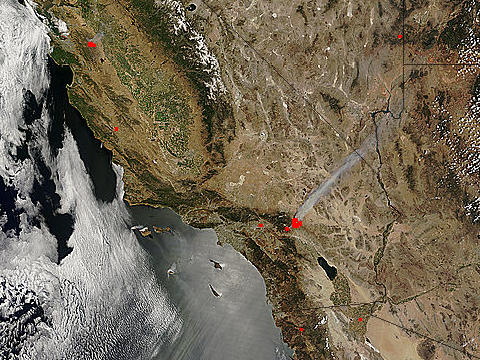
| Example |
| Here is an example to compare
the model with Shekell fire in southern CA |
|
|
|
|
|
|
| References |
|
|
McQueen, J.T.; and Draxler, R.R. (1994). Evaluation of model back
trajectories of the Kuwait oil fires smoke plume using digital satellite
data. Atmos. Environ., 28(13):2159-2174. |
|
|
Page last edited 20 December 2006
|

