|
Tribal Assessment |
|
The Columbia Plateau |
|
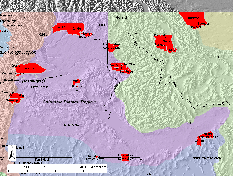
| Since we wanted to
statistically derive a correlation matrix for each region, we needed at
least four sites to in the correlation. There are six sites within
the region based on the physiographic boundaries. IMPROVE and IMPROVE
protocol sites used in this analysis are shown in this
map. |
|
| The details of the
correlation analysis are provided in tabular format below. The
Representative Distance (Rep. Dist.) is 106 km for this region.
Representative distances were based from exponential curve fits to the
correlation verses
distance curves. |
|
| Region |
|
Sulfate |
NO3 |
OMC |
LAC |
Soil |
CM |
Rep. Dist. |
| Columbia Plateau |
Distance (km) |
156.0 |
63.7 |
92.4 |
77.7 |
172.0 |
124.7 |
|
| |
Average (Mm-1) |
6.4 |
6.2 |
7.4 |
2.1 |
0.8 |
2.8 |
|
| |
Weighting |
0.248 |
0.241 |
0.289 |
0.081 |
0.031 |
0.110 |
|
| |
Weighted Dist. (km) |
38.7 |
15.4 |
26.7 |
6.3 |
5.4 |
13.7 |
106 |
|
|
| Based on a representative
distance of 106 km, seven tribal areas in the region are not represented by
an IMPROVE or IMPROVE protocol site as shown in this
summary map. |
|
 |
|
|
The following class I area is in the Columbia Plateau:
Craters of the
Moon
Eagle Cap Wilderness
Jarbidge Wilderness Area
Strawberry
Mountain Wilderness
The following IMPROVE sites are in the region:
Spokane
Tribe
|